Montana’s state parks provide a peaceful escape from busy national destinations. These parks welcomed 3.1 million visitors in 2023, showing a 42% increase in the last decade. Glacier and Yellowstone might be famous, but Montana’s 55 state parks offer amazing natural wonders with smaller crowds.
Nature lovers can discover Montana’s rich landscapes in these hidden gems. Pictograph Cave reveals ancient rock art, while Thompson Chain of Lakes spans 3,000 acres with 18 different lakes. The parks let visitors enjoy hiking, camping, fishing, and wildlife watching in preserved areas. Giant Springs State Park stands out as the most visited destination, drawing nearly 585,000 visitors last year. The park’s main attraction is one of America’s largest freshwater springs that produces 156 million gallons of water daily. Makoshika, Montana’s largest park, features 11,538 acres of badlands rich with dinosaur fossils.
This piece explains five must-visit state parks to help travelers plan their 2025 Montana adventure. These parks showcase the Treasure State’s natural beauty and outdoor experiences best.
Pictograph Cave State Park

Image Source: Montana FWP
A rich source of prehistoric art and archeological wonders sits just a few miles from Montana’s largest city. Pictograph Cave State Park shows proof of human habitation that goes back thousands of years. This 23-acre site became a National Historic Landmark in 1964 and gives visitors an amazing look into Montana’s ancient past through its rock art and archeological finds.
Pictograph Cave State Park location and accessibility
The park sits 5-7 miles southeast of Billings, Montana, making it easy to reach for anyone wanting to explore this archeological wonder. Visitors can take exit 452 from Interstate 90 at Billings’ east end onto Old Highway 87, turn right onto Coburn Road, and drive about 5-6 miles to reach the park. You’ll find it tucked into a sandstone bluff along an ancient path that runs south from where Bitter Creek meets the Yellowstone River.
The grounds sit at 3,500 feet above sea level and come with modern comforts despite their ancient appeal. The park offers picnic spots, vault toilets, grills, fire rings, trash cans, and drinking water. The staff has made sure people with disabilities can enjoy their visit with ADA-compliant restrooms and parking spaces.
People using wheelchairs can access the visitor center, parking area, water fountain, and restrooms easily. The trails offer mixed access – the first 0.15 miles of paved concrete path works best for wheelchairs, though some parts have moderate to steep slopes that might need help. Many visitors with mobility issues say strong helpers can guide them through tougher spots, especially one section that goes up at more than a 45-degree angle.
The park’s seasonal hours are:
- Summer Hours (Third Friday in May-Third Sunday in September): Open daily from 9 am to 7 pm
- Winter Hours (Third Monday in September-Third Thursday in May): Open Wednesday through Sunday from 9 am to 5 pm, closed Mondays, Tuesdays, and major holidays
The visitor center runs on a different schedule:
- Summer: Open daily 10 am to 5 pm
- Winter: Open Wednesday through Sunday 10 am to 4 pm
Montana locals get in free with their annual vehicle registration, while others pay $5 per vehicle.
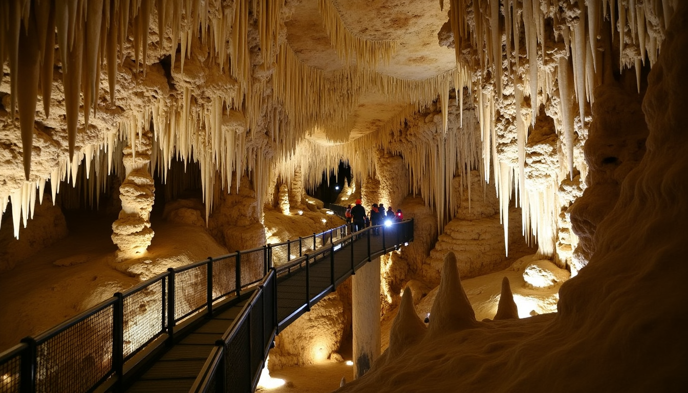
Ancient rock art at Pictograph Cave State Park
Three main caves make up the park’s archeological heart—Pictograph, Middle, and Ghost—shaped by water and wind in Eagle sandstone. Pictograph Cave stands out as the largest at 160 feet wide and 45 feet deep. You can see all three caves, but only Pictograph Cave has visible rock art.
The site’s story began in 1936 when Depression-era Works Progress Administration workers started digging. Oscar Lewis, an amateur archeologist, led the first digs, followed by William Mulloy, a professional who found about 30,000 artifacts from stone tools and weapons to paintings and art tools. Mulloy’s work led to the first complete archeological report about the Northwestern Plains in 1951.
The cave walls hold more than 100 paintings that tell stories of prehistoric life. The oldest artwork dates back over 2,000 years, with the newest pieces made 200-500 years ago. These drawings show animals, warriors, hunters and even rifles and horses—showing how European settlers influenced the area.
Scientists look at the colors—mostly red, black, and white—to learn when different groups lived here and how they lived. People used these caves for at least 5,000 years, likely including Apsáalooke (Crow) tribe’s ancestors who lived here since at least 1700, along with other tribes.
Bring binoculars to see the pictographs better. The artwork shows up best after rain or snow melts because moisture makes the drawings clearer.
Interpretive trails at Pictograph Cave State Park
A well-laid-out trail system lets you explore this historic site. The main loop runs about 3/4 mile and links all three caves—Pictograph, Middle, and Ghost. Signs along the way explain the natural features, prehistoric paintings, and local plants.
The trails include:
- Pictograph Cave Trail: A paved 1/4-mile path straight to the main cave with historic pictographs
- Ghost Cave Trail: An unpaved path leading to more caves with history signs
- Loop Trail: Links all three caves with great views around
Plan to spend at least an hour here to enjoy both the visitor center and trails. The paths offer great spots to watch birds and wildlife too.
Remember, you won’t go inside the caves. Instead, trails lead to spots where you can look at them from outside. The cave floors you see today sit lower than they used to because of the big digs in the late 1930s.
Start your visit at the modern visitor center, which has displays about the park’s history and first inhabitants. These exhibits help explain what you’ll see on the trails. You can also buy souvenirs at the gift shop.
The park runs educational programs throughout the year. Dogs can visit on leash but can’t go in the visitor center unless they’re service animals. Bikes aren’t allowed on trails to protect the archeological sites.
You can’t camp here—it’s just for day visits. Still, with its mix of archeological treasures, natural beauty, and learning opportunities, Pictograph Cave State Park stands out as one of Montana’s best connections to its prehistoric past and ranks among Montana’s must-visit state parks for 2025.
Thompson Chain of Lakes State Park

Image Source: Montana FWP
Blue pearls dot the northwestern Montana landscape as Thompson Chain of Lakes State Park stretches roughly 20 miles along Highway 2 between Kalispell and Libby. This 3,000-acre park gives you access to 18 unique lakes, making it one of Montana’s most diverse water recreation spots.
Thompson Chain of Lakes State Park location and accessibility
Thompson Chain of Lakes State Park lies in Montana’s scenic northwestern corner along Highway 2. The park makes a perfect stop between Kalispell and Libby. These stunning lakes stretch 17-20 miles, with many spots to access them along this scenic route.
The park welcomes visitors from major cities, though you’ll need to plan your trip. Here’s how long it takes to get there:
- 2 hours 39 minutes from Missoula
- 2 hours 52 minutes from Coeur d’Alene
- 3 hours 22 minutes from Spokane
- 4 hours 48 minutes from Lewiston
You’ll find the park at 48.02725295 N, 115.05038767 W. GPS makes it easy to locate. Lake access varies throughout the park. Some spots let you park right by the water, while others need a short walk from designated lots.
New visitors should know that many park roads are primitive. Large RVs and trailers might have trouble. Logan State Park on Middle Thompson Lake has spots for bigger camping units.
Cell service can be spotty throughout the park. It’s best to plan for limited communication during your stay.
Water recreation at Thompson Chain of Lakes State Park
The lakes are the real stars here. They range from tiny three-acre ponds to massive 1,300-acre waters. Both warm and cold-water environments create different ways to enjoy the water all season long.
Boaters will love the concrete boat ramps at key spots around the park:
- Little McGregor Lake
- Boisverts on McGregor Lake
- The Peninsula on Lower Thompson Lake
- Upper Thompson Lake
- Horseshoe Lake
- Loon Lake
These well-kept launches work great for all kinds of boats, from kayaks to motorboats. Lakes throughout the chain have concrete or dirt ramps, giving you options based on your needs.
Swimming is a big hit here, thanks to the warm-water lakes. Logan State Park’s public beach makes a great spot for families with young kids. Summer temperatures hit around 80°F, perfect for water fun.
Middle, Lower and Upper Thompson lakes connect, letting adventurous boaters explore further. Kayakers love paddling between lakes and checking out small inlets where bigger boats can’t go. The park’s waters are great for water skiing, canoeing, or just floating peacefully.
McGregor Lake leads the pack at 1,328 acres, while Lilly Pad Lake offers a cozy three-acre paddle. Different lake sizes and depths naturally spread out activities, keeping things from getting too crowded even in peak season.
Camping and fishing at Thompson Chain of Lakes State Park
The park offers plenty of camping choices, from basic sites to more developed spots. You’ll find 83 standard campsites and 8 group sites spread across the lakes. Most sites stay pretty rustic, with fire pits and picnic tables, but no drinking water.
Logan State Park on Middle Thompson Lake stands out with 37-39 campsites that fit larger rigs up to 40 feet. McGregor Lake Campground has 15 sites for trailers up to 32 feet. Most sites come with:
- Fire pits
- Picnic tables
- Vault toilets
You’ll need to pay to camp overnight, and camping only happens in the 60 marked sites around the chain. Campers often praise the spacious, well-kept grounds.
Fishing draws many visitors here, thanks to the variety of fish in these waters. The chain supports both warm-water game fish and cold-water trout. Popular catches include:
- Rainbow, brook, brown, and cutthroat trout
- Largemouth and smallmouth bass
- Northern pike
- Kokanee salmon
- Yellow perch
- Lake trout
- Whitefish
- Pumpkinseed
Each lake has its specialty. Upper Thompson Lake (375 acres, 50 feet deep) holds yellow perch, northern pike, largemouth bass, pumpkinseeds, rainbows, and smallmouth bass. Middle Thompson Lake spans 560 acres and sees the most fishing action among the three Thompson Lakes.
The three Thompson Lakes have made a name for great largemouth bass fishing. Both spin and fly fishing work well throughout the chain. Many lakes work great for shore fishing, though small boats, rafts, fishing kayaks, and pontoon boats help reach deeper spots.
Ice fishing gets popular when weather permits. Fall brings the best wildlife viewing, with chances to spot elk, whitetail deer, mule deer, and lots of birds.
Montana residents who pay the $9.00 state parks fee with yearly vehicle registration get in free. Others pay $8.00 per vehicle or $4.00 for walk-ins, bikes, or bus passengers.
The park’s size and variety make it worth staying several days to really see different lakes and activities. Seven lakes are bigger than 35 acres and deeper than 160 feet. Thirteen lakes sit completely on public land, giving you great access to nature throughout this amazing Montana state park.
Lone Pine State Park

Image Source: Montana FWP
Lone Pine State Park sits high above the Flathead Valley and offers breathtaking 360-degree views that showcase Montana’s diverse landscapes. This 279-acre natural sanctuary has been around since 1941, making it Montana’s second oldest state park. The park gives visitors recreational opportunities and panoramic vistas that stay in their memories long after they leave.
Lone Pine State Park location and accessibility
The park lies just 5 miles southwest of Kalispell, making it easily reachable for residents and tourists in northwestern Montana. Visitors can find the park by driving 4 miles southwest of Kalispell on Foys Lake Road and continuing 1 mile east on Lone Pine Road. Downtown Kalispell is only 10 minutes away, which makes the park perfect for quick nature escapes.
The park’s elevation ranges from 2,959 feet to 3,644 feet, creating diverse terrain that adds to its natural beauty and scenic value. Its 270 acres of protected land give plenty of room to explore without crowds, even though it welcomed 132,054 visitors in 2023.
The park added an Action Trackchair recently – an all-terrain wheelchair designed for visitors with mobility limitations. This specialized equipment stays on-site and visitors can use it free of charge with advance booking. Users need a non-disabled companion and can access the main Lone Pine trail system and ADA-accessible overlook. This addition helps create a more welcoming space for visitors of all abilities.
Winter visitors can rent snowshoes at $5.00 per person or $10.00 per family, which lets them enjoy the park year-round.
Scenic views from Lone Pine State Park
Lone Pine State Park’s dramatic vistas are its crown jewel—offering a unique panorama that sets this destination apart. Clear days let visitors see across the Flathead Valley to Flathead Lake, Big Mountain, the Jewel Basin, and even Glacier National Park in the distance. These spots make perfect locations for photography, quiet reflection, or simply taking in Montana’s natural beauty.
The park has several scenic overlooks that show different angles of the surrounding landscape. The Raptor’s Rest trail’s eastern side gives particularly stunning valley views. Many visitors find these panoramic vistas worth the trip alone, as they showcase northwestern Montana’s geographical diversity.
The visitor center adds to this experience with its spacious meeting room and wrap-around decks that display beautiful views. This building serves as both a learning space and gathering place, helping visitors understand the landscapes they see from the park’s high vantage point.
Wildlife and hiking at Lone Pine State Park
The park features 7.5 miles of trails that support various activities like hiking, mountain biking, snowshoeing, and horseback riding. These paths range from wide, well-surfaced trails to challenging single-track routes, giving options for every skill level. Mountain bikers can use about two-thirds of the trails, while the rest stay reserved for hikers.
Popular routes include:
- Lone Pine Trail: A 2.9-mile trail with 669 feet of elevation gain, rated 4.5 stars from 580 reviews
- Western Larch and Cliff Trail Loop: Features 662 feet of elevation gain with similar challenges
- Raptors Rest and Cliff Trail Loop: Takes you through forests and rocky ridgelines, perfect for birdwatching
Four trailheads give access to the trail system, with the Visitor Center/main park entrance serving as the best starting point. The visitor center staff can provide trail maps and suggest routes based on your interests and abilities.
Wildlife watching draws many visitors to Lone Pine, especially for bird species and raptors, along with seasonal wildflowers. The park’s ecosystem supports wildlife viewing throughout the year, and many trail sections offer quiet woodland settings perfect for observation.
Families or casual hikers can enjoy the main Lone Pine trail system’s accessible routes with educational elements. More adventurous visitors might combine trails like Western Larch, Lone Pine, Raptor’s Rest and Cliff trails into longer adventures through different park areas.
The park offers regular adult workshops, children’s activities, and educational programs that enhance visits, making it great for school field trips and learning outings. This mix of natural beauty, accessible trails, and educational opportunities creates a destination that appeals to many interests.
Lone Pine State Park’s location near Kalispell, amazing views, and well-kept trail system make it an ideal natural retreat where visitors can rejuvenate while experiencing Montana’s most beautiful landscapes. This historic state park offers memorable experiences with Montana’s natural heritage, whether you want challenging hikes, quiet reflection spots, or accessible outdoor adventures.
Cooney State Park

Image Source: Montana FWP
Cooney State Park ranks among Montana’s favorite water recreation spots. The sparkling reservoir sits just 40 minutes south of Billings. This 52-year old, 309-acre sanctuary lets visitors enjoy activities year-round. The park shows off Montana’s state parks versatility with summer water sports and peaceful winter fishing against the stunning Beartooth Mountain Range.
Cooney State Park location and accessibility
The park wraps around Cooney Reservoir, a 1,078-acre impoundment created in 1937. Red Lodge Creek was dammed to store water for the Rock Creek Water Users Association. Two well-marked routes lead to the park. Visitors from Laurel can drive 22 miles southwest on US Highway 212, turn west at Boyd, and continue 8 miles on county roads. Those coming from Columbus have a shorter route – 4 miles south to Shane Creek Road, followed by 14 miles east.
The park sits about 14 miles south of Columbus in Carbon County. Its location makes it perfect for day trips from Billings, Montana’s largest city. Perched at 4,252 feet, visitors can enjoy spectacular views of the Beartooth Mountain Range while they play.
The gates stay open all year. Winter visitors should check road conditions since snow drifts can make driving tricky. Non-residents pay $6.00 per vehicle or $4.00 for walk-ins and cyclists. Montana residents who pay the state parks fee with their annual vehicle registration get in free.
Boating and fishing at Cooney State Park
The 733-acre reservoir serves as the park’s crown jewel. Three boat ramps with docks give water enthusiasts easy access. Boats of all types find plenty of room – from motorboats and jet skis to canoes and kayaks.
Summer brings water skiing, wakeboarding, and jet skiing enthusiasts. The reservoir gets busy since it’s one of the few still water bodies nearby. Paddlers and swimmers can find safer spots in the shoreline’s “no wake zones.”
Fish lovers flock to Cooney. Montana Fish, Wildlife & Parks stocks the reservoir with rainbow trout and walleye. The park’s reputation for excellent fishing draws anglers throughout the year. A fish cleaning station at the Red Lodge Arm makes processing catches easier. Beyond trout and walleye, anglers can catch suckers and black crappie.
Winter brings new adventures. Ice fishing takes center stage when conditions allow. Cross-country skiing trails give cold-weather enthusiasts more options to explore.
Camping facilities at Cooney State Park
Five campgrounds spread 82 campsites around the reservoir. This setup creates a perfect base for longer stays. Nineteen sites offer electrical hookups year-round, though water service stops during winter.
Campers can enjoy these amenities:
- Fire rings with grills
- Picnic tables
- Both flush and vault toilets
- Fish cleaning station
- Drinking water (seasonal)
- Playground
- Coin-operated showers
Large groups can use three day-use areas. Stays max out at 14 days within any 30-day period to keep things fair for everyone.
Nightly fees range from $4.00 to $34.00 depending on amenities. Standard sites fit up to eight people and usually one camping unit. Double sites can handle up to sixteen people and two camping units.
Three of the five camping areas welcome wheelchair users. The park stretches across three sides of the reservoir. This layout lets campers pick spots based on what they want to do – whether that’s fishing, swimming, or soaking in the views.
Milltown State Park

Image Source: Montana FWP
Milltown State Park, Montana’s newest state park, sits where the Clark Fork and Blackfoot rivers meet. This 635-acre reclaimed space stands as proof of successful environmental restoration. The park has transformed from a century-old dam site with a contaminated reservoir into a thriving natural area.
Milltown State Park location and accessibility
The park spreads across western Montana near Missoula. Visitors will find restored river bottoms, mature cottonwood stands, pine forests, and striking rock cliffs throughout its diverse terrain. Multiple entrance points make the park available to visitors from various directions.
The park has three main areas:
- The Overlook: Panoramic river views with interpretive displays and picnic tables
- The Confluence Area: Riverfront trails and an interpretive plaza
- The Gateway Area: Links to the Confluence Area through a paved trail
Summer park gates welcome visitors from 9:00 a.m. to 9:00 p.m. between May and August, with shorter hours in spring and fall. Year-round sunrise-to-sunset access remains available for walk-in areas.
Restoration and conservation at Milltown State Park
The park’s story began as a Superfund site that went through major environmental rehabilitation. The 2008 dam removal cleared 6.6 million cubic yards of mining contamination. This project ranks among the West’s greatest restoration wins, eliminating arsenic threats from local wells permanently.
Native trout now thrive in cold, clean, connected waterways after the restoration joined the Middle and Upper Clark Fork watersheds. The park serves as a living laboratory where thousands of students, from elementary to graduate level, study river restoration and ecology.
Trails and river access at Milltown State Park
Hiking trails stretch three miles from the Overlook down to the Clark Fork River and its floodplain. A paved trail runs along the lower Blackfoot River’s edge, linking the Confluence and Gateway areas.
The park becomes a hub for the famous “tube hatch” during July and August. Thousands of floaters and paddlers head over to escape Missoula’s summer heat. Visitors should note the park allows only day-use facilities without overnight parking.
The park’s growth continues steadily. New land along the Clark Fork joined the park in 2020, with trail expansion plans set for the historic Bandmann Flats property. Milltown stands unique as the country’s only former Superfund site that became a state park.
Conclusion
Montana’s natural treasures shine brightly in these five amazing state parks you can visit in 2025. Glacier and Yellowstone are famous spots, but the state parks offer equally amazing experiences with fewer tourists. These destinations let you see everything from thousand-year-old pictographs to crystal-clear alpine lakes that are perfect for outdoor fun.
Pictograph Cave serves as a gateway to prehistoric Montana. The ancient artwork on its walls tells stories of people who lived there before written history began. Thompson Chain of Lakes is a paradise for water enthusiasts with 18 different lakes that provide great fishing and boating. Lone Pine’s trail network gives you stunning views of the Flathead Valley from every angle. Cooney State Park draws people who love water activities with the beautiful Beartooth Mountains as their backdrop. Milltown might be the newest park, but it shows nature’s amazing ability to bounce back through restoration.
Montana’s park system protects many more natural and cultural treasures across its 55 locations. These preserved lands offer something special for everyone – from families and outdoor lovers to history buffs and casual visitors. The state’s steadfast dedication to conservation will give future generations a chance to enjoy these special places, while today’s visitors can experience authentic Montana away from busy tourist spots.
When you head to Montana in 2025, take time to learn about these less-crowded spots. The best memories often come from places where you can hear nature’s whispers without the tourist chatter. Montana’s state parks are definitely those kinds of places.