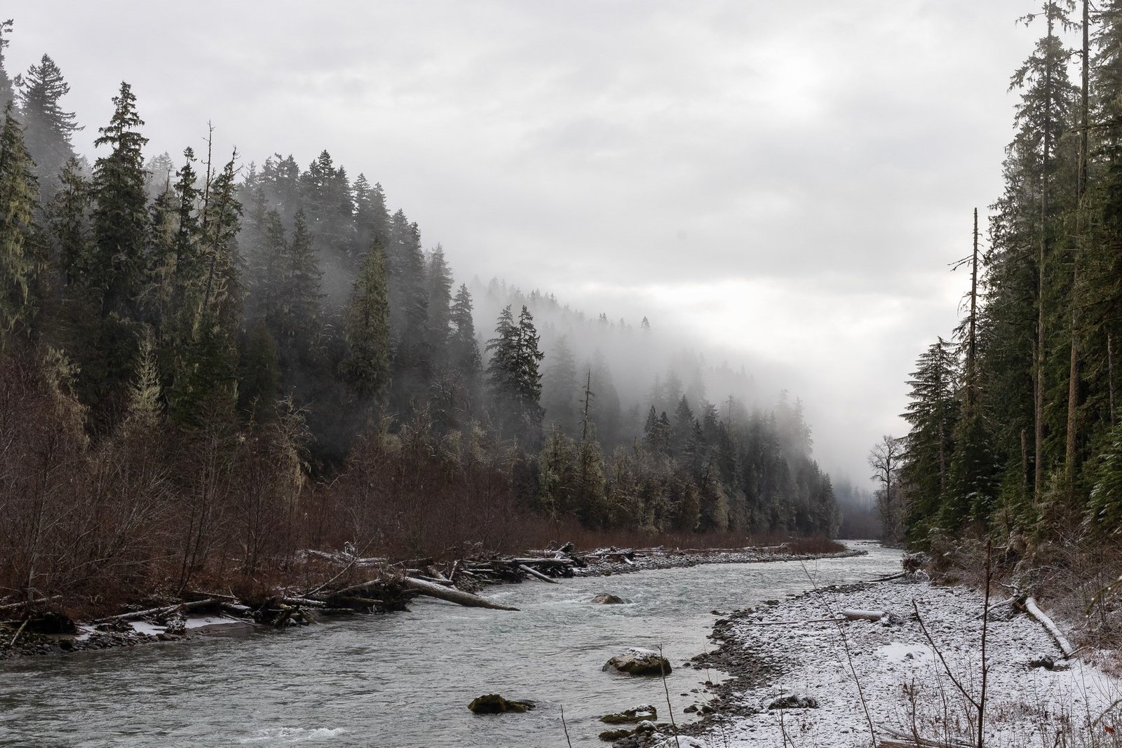
Oregon hiking attracts locals and visitors who seek outdoor adventure. Oregonians love hitting the trails. The landscape bursts into life during summer months. Silver Falls State Park spans 9,000 acres of natural beauty and stands as the crown jewel of Oregon’s state park system.
Hikers looking for Oregon’s best trails can choose between cascading waterfalls and coastal vistas. The state’s varied natural terrain caters to every type of hiker through trails that rank high among travelers’ favorites. Summer brings crowds to popular paths. Yet winter and spring deliver the most rewarding experiences on many Oregon hiking trails. This rings true especially when water levels rise and bright green moss covers the forest floor. The 177-foot South Falls and historic Columbia River Highway State Trail lead the list of five stunning locations that prove Oregon’s status as a premier hiking destination.
Trail of Ten Falls (Silver Falls State Park)
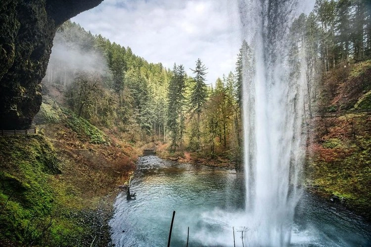
Image Source: Oregon State Parks – Oregon.gov
Silver Falls State Park boasts one of America’s most impressive waterfall day-hikes and stands as the crown jewel of Oregon’s state park system. This natural wonder spans over 9,000 acres and gives hikers the unique Trail of Ten Falls, where cascading water and lush forest create an unforgettable hiking trip.
Trail of Ten Falls overview
The Trail of Ten Falls, a National Recreation Trail, combines the Canyon Trail and Rim Trail into a magnificent loop through Silver Falls State Park. Just 1.5 hours from Portland and 40 minutes from Salem, this available trail draws waterfall enthusiasts, photographers, and hikers year-round.
The trail’s extraordinary feature lies in its concentration of waterfalls—all connected by a single path. Unlike the Columbia River Gorge where waterfall viewing needs multiple stops and parking spots, hikers can experience numerous cascades in one continuous trip. The loop format will give a fresh view throughout the adventure instead of backtracking.
South Falls Lodge Trailhead serves as the main starting point, though North Falls Trailhead works as an alternative. The South Falls area’s amenities include restrooms, a café, and a gift shop that boost the overall visitor’s experience.
Trail of Ten Falls highlights
Ten magnificent waterfalls are the trail’s namesake feature. These waterfalls range from 27 feet to 178 feet tall, each with unique characteristics that make them photogenic. Five of these natural wonders stand taller than 100 feet.
The trail’s most remarkable aspect lets you walk behind four waterfalls—South Falls, Lower South Falls, North Falls, and Middle North Falls. The waterfalls’ geological formation creates this unusual feature. Water flows over thick basalt lava that rests on softer rock, which eroded over time to create natural amphitheater-like spaces behind the cascading water.
South Falls, the park’s second-highest waterfall at 177 feet, has the tallest single drop. This stunning cascade ranks with Multnomah Falls and Punch Bowl Falls as one of Oregon’s most photographed waterfall scenes. A bench inside the grotto behind South Falls gives hikers a peaceful spot to rest and soak in the powerful beauty above.
Trail of Ten Falls difficulty & distance
The Trail of Ten Falls stays available to hikers of various experience levels despite its impressive scope. The full loop extends between 7.2 and 7.8 miles, depending on whether you take all small spur trails to viewpoints. Most people complete the trip in 3 to 5 hours, though some take longer to appreciate each waterfall.
The trail’s elevation gain ranges from 800 to 1,300 feet, making it moderately challenging. Experienced hikers often say the climb feels gradual, with just a few steeper sections. The trail’s length creates more challenge than technical difficulties or extreme terrain.
Families with older children often tackle the full loop. Those wanting shorter options can use connector trails. Maple Ridge Trail and Winter Trail work as shortcuts that cut the overall distance while letting visitors see several waterfalls. A five-mile shortened loop shows seven of the ten falls.
Best time to visit Trail of Ten Falls
The trail stays open year-round, and each season brings its own charm. Spring months (April through May) show the most dramatic waterfall displays as higher water levels from rain and snowmelt create powerful cascades. Spring also brings lush greenery with fewer crowds than summer.
Summer (June through September) brings reliable sunny weather and dry trails but draws the biggest crowds, especially on weekends. Late summer might see some waterfalls reduce to a trickle from less rainfall. All the same, cool mist from the falls helps on hot days.
Fall alters the map with vibrant foliage, usually peaking mid-October. Golden and crimson leaves create stunning contrasts with the waterfalls that fascinate photographers. Fall’s increased rainfall revitalizes the falls after drier months.
Winter mixes challenges with rewards. Waterfalls appear dramatically powerful, and some partially freeze during cold snaps. But trails get slippery with ice and snow, especially in shaded spots and near waterfalls where spray freezes. Winter hiking needs microspikes or similar traction devices.
Tips for hiking Trail of Ten Falls
These practical tips will help you enjoy the Trail of Ten Falls:
- Start early or pick weekdays: Beat crowds by starting before 9:00 am, ideally on weekdays. South Falls parking fits 300-400 cars but fills fast on weekends and holidays.
- Pay the fee: You need a USD 5.00 day-use parking permit. South Falls day-use area takes credit cards, but North Falls needs cash. Oregon residents might want an annual state parks pass for USD 30.00.
- Pick your direction: Many trail veterans suggest taking the trail clockwise from South Falls for better waterfall views.
- Get ready for conditions: Trails often turn muddy and slippery, so wear sturdy shoes with good grip. Rainy seasons and winter need waterproof gear since you’ll get wet from rain and walking behind waterfalls.
- Know pet rules: Dogs can only use the Rim Trail part of the loop, not the Canyon Trail where most waterfalls sit. This hike works better without pets.
- Pack essentials: Bring at least one liter of water per person, snacks, and a camera. Limited cell service means downloading trail maps beforehand.
- Look into overnight stays: The park’s campground offers about 90 sites and cabins for longer explorations.
The Trail of Ten Falls shows why Oregon ranks among America’s best hiking spots. Its manageable terrain, amazing waterfall concentration, and year-round appeal create a quintessential Pacific Northwest experience that fascinates visitors nationwide and beyond.
Green Lakes Trail (Cascade Lakes Scenic Byway)

Image Source: Visit Central Oregon
Green Lakes Trail flows through Central Oregon’s pristine wilderness and stands as one of the region’s most beloved hiking spots. The trail runs along the spectacular Cascade Lakes Scenic Byway and lets adventurers find alpine lakes, volcanic landscapes, and panoramic mountain views that showcase Oregon’s diverse beauty.
Green Lakes Trail overview
The Green Lakes Trail starts at the Green Lakes/Soda Creek Trailhead, about 27 miles west of Bend (roughly a 40-minute drive) right off the Cascade Lakes Scenic Byway. This trail has earned its spot as one of Central Oregon’s favorite hiking destinations. The path winds through different landscapes and manages to keep a gentle elevation gain, making it available yet rewarding for hikers of all skill levels.
The trail’s appeal comes from its perfect mix of distance and reward. Many hikes save their best views for the end, but this trail gives you amazing scenery from start to finish. You’ll see flowing creeks, cascading waterfalls, lava flows, mountain vistas, and the stunning emerald-colored lakes that give the trail its name.
Hikers need a Central Cascades Wilderness Permit between June 15 and October 15, which helps protect the natural environment by managing visitor numbers. The trailhead parking requires either a Forest Pass (USD 5.00 per day or USD 30.00 annually) or America the Beautiful pass (USD 80.00 annually).
Green Lakes Trail highlights
The trail engages hikers with natural wonders from the very start. The first few miles follow Fall Creek, with its cool waters keeping you company for most of your experience. About 0.6 miles from the trailhead, you’ll find Fall Creek Falls – a beautiful cascade that sets the tone for what’s ahead.
The path then runs along a dramatic lava flow – a reminder of the volcanic forces that created this landscape. Dark, rugged lava contrasts with surrounding greenery to create a unique scene that defines Oregon’s volcanic territory.
The real treasures wait at the trail’s peak: three emerald-green alpine lakes nestled between South Sister and Broken Top mountains. These lakes aren’t just pretty to look at; minerals in the water create their distinctive green color, making them look like jewels against the mountain backdrop. The biggest Green Lake shows off South Sister’s best side, while the third lake has a sandy shore that’s perfect for a chilly dip.
Late July and early August bring wildflowers that paint the landscape with bright colors. These blooms mix with mossy forests that remind you of Oregon’s coast, creating an unexpectedly rich environment in what could be high desert terrain.
Green Lakes Trail difficulty & distance
The trail stays available to moderately experienced hikers despite its reputation as one of Oregon’s best hikes. The main route runs about 9-9.5 miles round-trip to the first two lakes, stretching to 11 miles if you visit all three lakes.
You’ll climb between 1,000 and 1,400 feet, depending on how far you explore around the lakes. Most hikers say it’s on the easier side of “moderate” because the climb spreads out over the whole trail instead of hitting you with steep sections.
A round trip usually takes 3.5 to 5 hours. Trail runners love this path because it’s wide, well-maintained, and free from technical challenges that might slow them down.
The trail also works great for overnight backpacking. About 22 marked campsites surround the lakes, each with a numbered post to protect the delicate alpine environment.
Best time to visit Green Lakes Trail
Summer is the best time to hike Green Lakes Trail, from late June through October. The snow usually melts by late June or early July, opening up the high-country lakes.
Wildflower lovers should come in late July through early August to see spectacular blooms along the path. September brings perfect conditions with mild temperatures, smaller crowds (especially after Labor Day), and stable weather.
Early to mid-October shows off fall colors and cooler temperatures before winter’s first snow. This short window lets you see the trail in autumn splendor before winter makes it hard to reach.
Each season has its quirks. Summer is great for swimming but might bring wildfires that affect air quality. Watch out for aggressive insects during summer months too.
Tips for hiking Green Lakes Trail
Get there early (before 9:00 am) to find parking, as spots fill up fast even during permit season. Summer hikers should book their Central Cascades Wilderness Permit well ahead since these limited passes sell out quickly.
Water management is easier here than on many trails. Fresh water runs along most of the route, so you can filter water instead of carrying it all. This really helps during hot months.
Pack for changing conditions. Summer brings biting insects, so bring bug spray and maybe head nets. Mountain weather changes fast, so wear layers.
Know the rules. Dogs can join you but need leashes between July 15 and September 15, except when swimming. Camp only in numbered sites to protect the delicate alpine ecosystem.
Bring the right gear. Besides hiking basics, trekking poles help on the way down when your knees might get tired. Don’t forget your camera for those amazing mountain and lake views.
Be a responsible visitor. The trail’s popularity means everyone needs to pack out their trash and follow Leave No Trace principles. Overnight campers should bring sturdy tents since exposed sites can get windy.
Green Lakes Trail shows why Oregon ranks among America’s best hiking spots – it offers beautiful scenery, diverse ecosystems, and mountain views that outdoor enthusiasts of any skill level will remember forever.
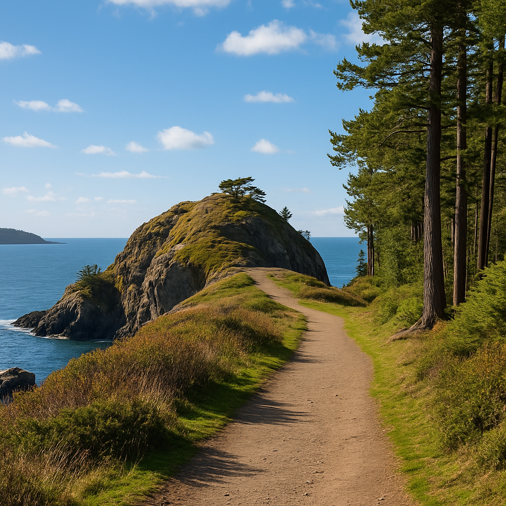
God’s Thumb via The Knoll (Oregon Coast)
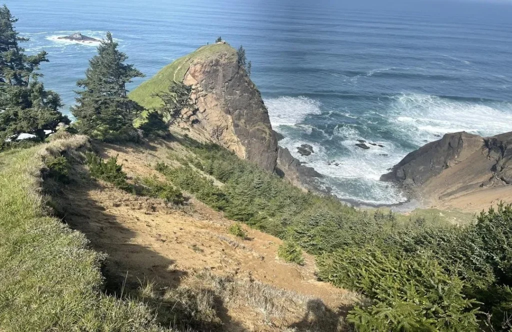
Image Source: AllTrails
God’s Thumb stands tall above Lincoln City’s shoreline as one of Oregon’s most unique coastal hiking spots. This thumb-shaped basalt formation stretches into the Pacific Ocean and gives hikers amazing panoramic views of Oregon’s beautiful coastline.
God’s Thumb trail overview
The God’s Thumb trail weaves through Lincoln City’s northern edge from The Knoll or Roads End State Recreation Site. This hidden gem stays off the usual tourist path and gives you a more peaceful experience than other Oregon hiking trails. The path takes you through a variety of coastal ecosystems – dense Sitka spruce forests, meadows full of wildflowers, and the exposed headland that makes up the iconic “thumb.”
The trail’s special feature is its geological makeup – a basalt outcrop created by ancient volcanic activity that has stood strong against ocean forces for centuries. Hikers can see why it got its name as they get closer to the top, which explains its place in native stories.
You’ll need to walk through some neighborhoods to reach the trailhead in a developing area. The trail might start near the city, but it quickly leads you to a place that feels far away from civilization.
God’s Thumb trail highlights
Your experience to God’s Thumb gets better with each step. The trail starts in coastal forests where moss-covered trees create a magical feel like old woodlands. Once you leave the forest, you’ll find yourself in wide meadows that burst with wildflowers during spring and early summer.
The Knoll comes next – a grassy hill before the final climb that gives you your first big views. From this natural lookout, you can see Cascade Head to the north and Lincoln City’s beach to the south, giving you a taste of what’s coming.
The best part waits at the trail’s end. The thumb gives you amazing 360-degree views that cover miles of rugged coast, the vast Pacific Ocean, and on clear days, you can spot the Coast Range mountains inland. Steep cliffs drop hundreds of feet to the ocean, creating perfect spots for photos that show off Oregon’s coastal beauty.
Bird watchers often spot native species here, including bald eagles riding the coastal winds. During migration seasons, you might even catch gray whales spouting offshore.
God’s Thumb trail difficulty & distance
The views are worth it, but God’s Thumb has some challenges you should be ready for. The full loop from Roads End State Recreation Site runs about 4.3 miles with an 800-foot climb. Starting from The Knoll cuts your trip to about 3 miles round-trip.
The trail’s difficulty changes with the weather. In dry weather, most parts are fine for average hikers. After rain – which happens often on the Oregon coast – some spots get really slippery and tricky, especially the steep part near the thumb.
Narrow trails along steep cliffs need careful steps as erosion keeps changing the path. The final climb isn’t technically hard but needs extra care, especially when it’s windy. Most people finish the round trip in 2-3 hours, depending on how long they stop for views.
Best time to visit God’s Thumb
The weather makes a big difference in your God’s Thumb hike. Summer months (July through September) usually have the best conditions with clear skies and dry trails. These months are perfect for photos and have fewer hazards from mud and erosion.
Spring fills the meadows with beautiful wildflowers, usually at their best in May and early June. It also offers great storm watching from the lower viewpoints.
Fall is great for people who want some quiet time since visitor numbers drop after Labor Day. The coastal plants change colors beautifully, though more rain starts affecting the trails.
Winter hikes to God’s Thumb are only good for experienced hikers with the right gear. Strong storms, high winds, and wet ground make it dangerous, especially near the top.
You should always check the weather right before hiking. The coast’s conditions change fast, and fog can roll in quickly, making it hard to see and easy to get lost.
Tips for hiking God’s Thumb
Here’s how to have a safe and fun time on this unique coastal trail:
- Wear good shoes with great grip – even experienced hikers struggle with mud and slippery spots
- Pack layers no matter what the forecast says – coastal weather changes fast and it gets windier up high
- Get an early start to avoid afternoon winds that can make the exposed summit uncomfortable or dangerous
- Keep to the trail to stop erosion and protect fragile plants that take forever to grow back
- Stay back from cliff edges that might give way, especially after heavy rain
- Bring trekking poles to help with steep, muddy parts
- Pack water and snacks since there’s nothing available on the trail
- Watch out for private property when getting to trailheads near homes
God’s Thumb shows why Oregon’s coastal trails are just as amazing as its mountain paths. This unique spot gives you forest peace, meadow calm, and dramatic ocean views – all in a half-day trip that’s perfect for hikers with some experience under their belt.
Misery Ridge Trail (Smith Rock State Park)
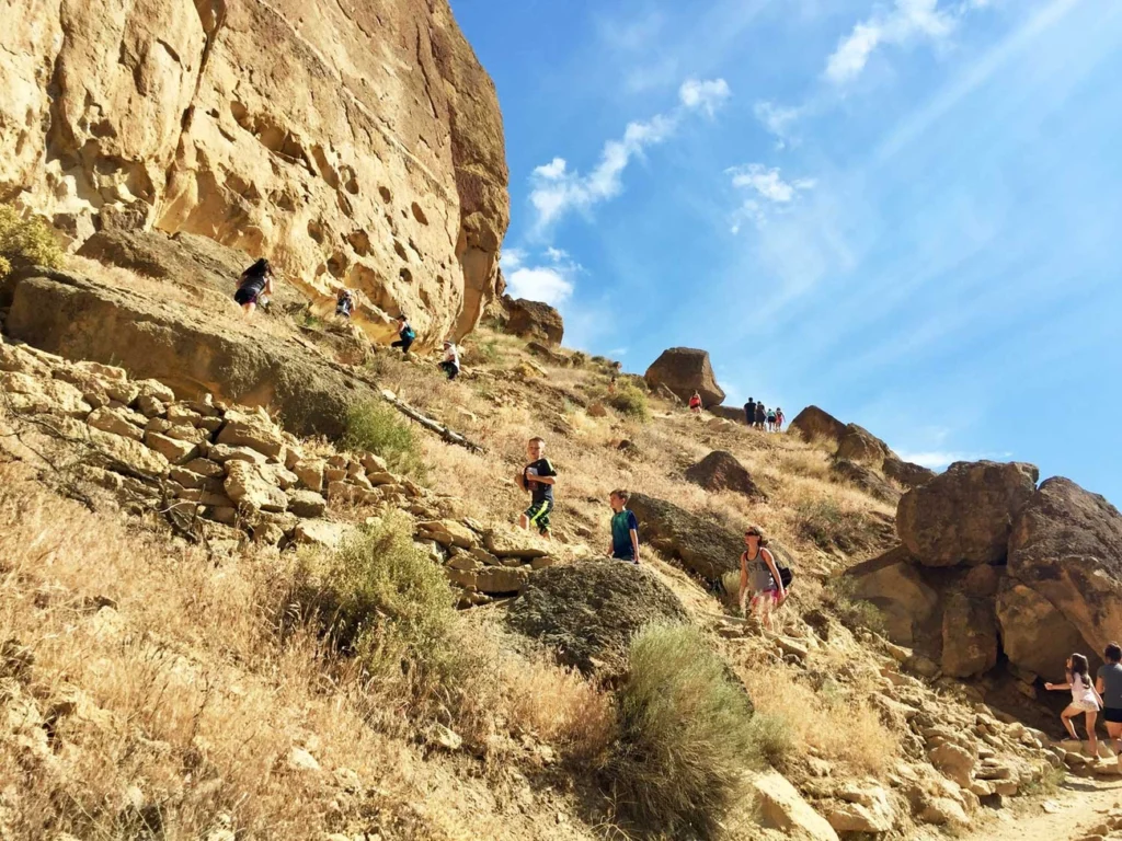
Image Source: Smith Rock State Park
Smith Rock State Park’s Misery Ridge Trail sits in Oregon’s high desert. This remarkable trail shows the state’s varied hiking terrain. Adventurers can explore dramatic volcanic landscapes while taking in stunning panoramic views. These views differ greatly from Oregon’s typical forest and coastal paths.
Misery Ridge Trail overview
The trail loops through Smith Rock State Park near Terrebonne and lets hikers experience Oregon’s volcanic past up close. Your trip starts at the Smith Rock Welcome Center. Cross a footbridge over the Crooked River before the real challenge begins. The trail’s name might sound scary, but moderately experienced hikers will find it challenging yet doable.
You’ll reach Monkey Face Peak on the Misery Ridge Path. The trail has steep sections with loose gravel and rocky ground. The park’s signature 600-foot sheer cliffs make this trail special. These cliffs are part of an eroded caldera created by a massive volcanic explosion 30 million years ago.
Misery Ridge Trail highlights
Spectacular views reward your climb. The panoramic vistas reveal the winding Crooked River below. On clear days, you’ll see the Cascade mountain range from Mount Bachelor to Mount Hood. These sweeping landscapes offer perfect photo opportunities throughout your trip.
Monkey Face stands out as the route’s most unique feature. This 350-foot free-standing welded tuff pillar looks like a primate’s profile. Rock climbers from everywhere come to tackle this formation. Hikers can watch these climbers work their way up various routes. The ridge often reveals wildlife such as deer and sometimes rattlesnakes.
Misery Ridge Trail difficulty & distance
The trail presents a moderate challenge. Distance varies based on your chosen route. The main out-and-back trail covers 2.6 miles with 1,138 feet of elevation gain. The popular loop option stretches to 3.7-4.1 miles. Most people finish the hike in 2-3 hours.
Steep inclines and steps make this trail challenging, especially during the first climb from the river. Loose gravel and rocky sections need proper footwear and careful steps. The name “Misery” reflects the trail’s demands, but its shorter distance makes it suitable for moderately experienced hikers.
Best time to visit Misery Ridge Trail
The trail offers its best conditions from March through October. Summer brings good weather but intense heat, and the trail has almost no shade. Morning hikes during summer months work best with cooler temperatures and fewer people.
Spring and fall temperatures stay moderate. Spring brings colorful wildflowers while fall shows beautiful color changes. Winter hiking works too but needs extra care because of possible ice. Sunrise and sunset hikes create amazing light for photos. Many hikers find sunset views from the ridge particularly beautiful.
Tips for hiking Misery Ridge Trail
Make your Misery Ridge hike better:
- Start early – Get there before 8:00 am to find parking and beat the heat
- Bring plenty of water – You’ll need good hydration for this dry, exposed trail
- Wear appropriate footwear – Good traction helps on loose gravel and scree
- Use trekking poles – These help you stay stable on steep parts and protect your knees going down
- Pay the fee – You need a USD 5.00 day-use parking permit all year
- Watch for wildlife – Look out for rattlesnakes during warm months
Misery Ridge shows why Oregon draws hiking enthusiasts worldwide. The trail’s volcanic landscape creates a striking difference from the state’s other natural settings while offering equally amazing beauty.
Tamanawas Falls Trail (Mount Hood National Forest)
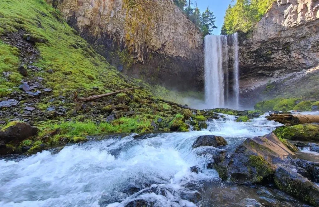
Image Source: AllTrails
Tamanawas Falls stands 110 feet tall against a dramatic basalt cliff. This stunning waterfall shows why Mount Hood National Forest draws hiking enthusiasts from all over Oregon. The falls create a constant mist that feeds the surrounding ecosystem and rewards hikers with a cool, refreshing break.
Tamanawas Falls Trail overview
“Tamanawas,” which sounds like “ta-MAH-na-was,” comes from the Chinook language and means “friendly guardian spirit”. The falls got their current name in 1971, replacing the original name Giffords Falls. The trail starts right off Highway 35, about 90 minutes from Portland. Hikers cross the East Fork Hood River and follow the crystal-clear Cold Spring Creek through rich ancient forests.
Tamanawas Falls Trail highlights
Cold Spring Creek dances over boulders, creating small cascades that hint at what’s ahead. You’ll walk through impressive groves of western red-cedar, Douglas-fir, and western larch trees. These larches turn golden in late October. The main falls create quite a show, as water crashes into a natural amphitheater with pink basalt walls. Bold hikers can walk behind the falls, but they’ll get soaked in cold mist.
Tamanawas Falls Trail difficulty & distance
The trail runs 3.4-4 miles round-trip with a climb of 550-600 feet. Most people finish the hike in 1.5-2.5 hours[242]. The path stays gentle except for one tricky talus slope just before the falls. This rocky part needs extra care, especially after rain.
Best time to visit Tamanawas Falls
The falls welcome visitors all year, with each season offering something special. Summer months (July-September) bring dry trails and strong water flow. Fall paints the landscape with vine maples turning bright red and yellow. Winter creates an amazing blue ice grotto, though you’ll need microspikes or snowshoes.
Tips for hiking Tamanawas Falls
- Get there before 9:00 am on weekends – the small lot fills up fast
- Get your Northwest Forest Pass (USD 5.00 daily or USD 30.00 annually) – it’s required May-October
- Wear waterproof hiking boots with good grip – you’ll need them on rocky sections
- Pack layers – the falls’ mist creates its own weather
- Bring trekking poles to help with balance on the talus section
Oregon’s Hiking Trails: Nature’s Masterpieces
Oregon is a paradise for hiking lovers with its rich and varied landscapes. The state’s cascading waterfalls, alpine lakes, coastal views, and volcanic terrain fascinate both casual walkers and seasoned adventurers.
The trails we’ll look at here show off Oregon’s natural beauty in different ways. Trail of Ten Falls lets you see the raw power and grace of multiple waterfalls in one hike. Green Lakes Trail shows you peaceful alpine scenes between tall volcanic peaks. God’s Thumb gives you amazing coastal views from its unique basalt formation. Misery Ridge Trail takes you through high desert landscapes with sweeping views of ancient volcanic features. Tamanawas Falls Trail leads to a grand cascade in a lush forest setting.
These trails might be different, but they share some key features hikers should know about. Oregon’s weather affects trail conditions by a lot. Summer brings sunshine and crowds to popular trails, while spring and fall have fewer people and beautiful seasonal colors. You’ll need to prepare well whatever trail you pick. Good boots, layers of clothes, enough water, and the right permits will keep you safe and happy on the trail.
New visitors to Oregon should think about their hiking skills before picking a trail. The moderate Trail of Ten Falls or Tamanawas Falls are great starting points that reward you with beautiful views without too much effort. Skilled hikers might want to take on the full Green Lakes loop or tackle God’s Thumb’s exposed sections.
Without doubt, these five trails are just the start of what Oregon has to offer outdoors. The state has hundreds more paths through old forests, along wild coastlines, and over volcanic landscapes. Each path tells its own story about Oregon’s geology and diverse ecosystems.
Remember to check trail conditions, get your permits, and follow all posted rules before heading out. These simple steps help keep these natural wonders beautiful for future hikers.
These five beautiful Oregon hiking spots are waiting for you. Which trail will you explore first?