Oregon’s state parks rank among the nation’s finest. These natural wonders have created a legacy of beauty and outdoor adventure that spans over a century. The park system celebrated its 100th anniversary in 2022 and continues to engage visitors with stunning views and endless recreational opportunities in a variety of landscapes.
The legendary 7.2-mile Trail of Ten Falls at Silver Falls State Park offers a genuine bucket-list experience for locals and tourists alike. Smith Rock boasts an impressive collection of over 1,500 climbing routes. These natural treasures have something for every outdoor enthusiast. You can take in Ecola State Park’s 230-degree Pacific Ocean panoramas, set up camp at one of The Cove Palisades’ two unique campgrounds along Lake Billy Chinook, or spot migrating whales from Cape Lookout’s five-mile spit. The state park campgrounds provide accommodation options such as cabins, yurts, and RV camping sites. Detailed Oregon state park maps and reservation systems make planning the perfect getaway simple.
Outdoor adventurers will find plenty to love in 2025. Fort Stevens welcomes hikers with 15 miles of trails. Anglers can cast lines in Wallowa Lake’s alpine waters. Families can enjoy La Pine State Park’s 14 miles of beginner-friendly paths. These destinations should be on every outdoor enthusiast’s list.
Silver Falls State Park

Image Source: Oregon State Parks – Oregon.gov
Silver Falls State Park, nicknamed the “crown jewel” of Oregon’s state park system, covers 9,200 acres in the Cascade Mountains’ foothills. This natural wonder stands as Oregon’s largest state park. More than 1.1 million people visit this park each year, which sits about 60 miles south of Portland.
Silver Falls State Park highlights
Ten magnificent waterfalls dot the park’s lush, forested canyons. South Falls, the most famous waterfall, drops an impressive 177 feet. Visitors can walk behind the shimmering curtains of water at four different falls. The park’s fascinating geology dates back 15 million years when Columbia River basalt flows created distinctive honeycomb columns that line the cliff edges.
Silver Falls State Park hiking trails
The Trail of Ten Falls serves as the park’s crown jewel – a moderate 7.2-mile loop that climbs 800 feet and passes all ten waterfalls. Shorter options include the Winter Falls Loop at 5 miles with seven waterfalls, and the Maple Ridge Loop spanning 2.6 miles with two falls. The North Rim Trail, which opened in July 2023, gives visitors an easy one-mile route with amazing views of North Falls.
Silver Falls State Park camping options
The main campground features:
- 48 electrical sites with water (18+ open year-round)
- 43 tent sites (seasonal, May-October)
- 14 cabins (7 pet-friendly, available year-round)
Howard Creek Horse Camp runs from May through September with five primitive sites that include horse stalls.
Silver Falls State Park accessibility
Recent improvements have made the park available to more visitors, especially at the new North Canyon Day-Use Area with its ADA-accessible restrooms and dedicated parking. The North Rim Trail stays at least six feet wide with packed gravel that works well for many mobility devices. Visitors can find two universally accessible campsites (B2 and B4) and four cabins.
Silver Falls State Park nearby attractions
The Oregon Garden ranks as the area’s most popular attraction, complete with botanical displays, a rose garden, and pet-friendly areas. Silverton’s charming downtown welcomes visitors with local shops, bakeries, and cafés. Salem’s Bush Garden and Bush House provide additional sightseeing options.
Silver Falls State Park visitor tips
Parking costs $5 per day throughout the park. The Canyon Trail and connecting paths don’t allow pets, but dogs can run free in the South Falls Day-Use Area. Waterfalls reach their peak flow during spring, while summer brings drier trail conditions. The South Falls Lodge Café welcomes hungry visitors daily from 10am to 4pm.
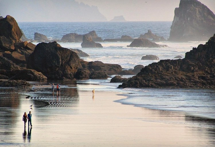
Ecola State Park

Image Source: Oregon State Parks
Ecola State Park sits on the edge of Tillamook Head, spanning 1,023 acres along 9 miles of Oregon’s beautiful coastline. This natural gem offers some of the Pacific Northwest’s most photographed and filmed landscapes.
Ecola State Park Features
The park has two main spots for day visits: Ecola Point and Indian Beach. Visitors at Ecola Point can take in sweeping 230-degree views of the coastline. Sea stacks dot the shoreline to the south, while the historic Tillamook Rock Lighthouse stands proud to the north. Movie buffs might recognize the park from films like The Goonies, Twilight, and Point Break. The entrance road winds through a thick Sitka spruce forest that opens up to grassy bluffs with stunning Pacific Ocean views.
Ecola State Park Hiking Trails
The park’s trails cater to different hiking abilities:
- Crescent Beach Trail: A moderate 2.5-mile out-and-back trail that shows off Sea Lion Rocks (190 ft elevation gain)
- Indian Beach Trail: A moderate 3.9-mile round-trip path with views of Ecola Point (840 ft elevation gain)
- Clatsop Loop Trail: A 3-mile trek following Lewis and Clark’s historic route (790 ft elevation gain)
- Tillamook Head Trail: A challenging 10-mile round-trip adventure (2,500 ft elevation gain)
Ecola State Park Camping Options
The park doesn’t have regular campgrounds. Backpackers on the Oregon Coast Trail can rest at Hikers’ Camp, which has three basic Adirondack-style shelters. Each shelter fits four people on wooden platforms. The park doesn’t allow overnight parking. Campers can find spots nearby at Cannon Beach and Nehalem Bay State Park.
Ecola State Park Accessibility
People with mobility needs can access viewpoints at Ecola Point and Indian Beach. The park provides wheelchair-friendly parking and restrooms [25, 26]. Most beaches and trails aren’t accessible due to rough terrain.
Ecola State Park Nearby Attractions
Cannon Beach sits just minutes away with its restaurants, shops, and famous Haystack Rock. Seaside Beach, Hug Point State Park, and Oswald West State Park are also close by.
Ecola State Park Visitor Tips
Daily entry costs $5-10, and annual Oregon State Parks permits work too. The park welcomes visitors from 8 AM to 5 PM. Smart visitors check road conditions before coming since landslides can cause closures. Dogs can explore most areas on leash. Gray whales pass by during their migration from December through June.
Smith Rock State Park

Image Source: Oregon State Parks
Smith Rock State Park towers above Oregon’s high desert with its volcanic ash spires that attract rock climbers worldwide. This 650-acre park, one of the “7 Wonders of Oregon,” offers much more than climbing adventures.
Smith Rock State Park highlights
Smith Rock is the birthplace of American sport climbing and has nearly 2,000 routes for climbers of all skill levels. Basalt and tuff cliffs rise dramatically from the Crooked River’s shores and create stunning contrasts with the high desert surroundings. The park’s remarkable terrain, shaped by volcanic activity and erosion, has become a world-renowned climbing destination.
Smith Rock State Park hiking trails
You’ll find several connected trails in the park:
- Misery Ridge Loop: A tough 3.7-mile route that climbs 1,500 feet and rewards you with amazing views of Monkey Face spire and the Cascade Range
- River Trail: A gentler 4.2-mile out-and-back path with just 150 feet of elevation change
- Summit Trail Loop: A challenging 7.3-mile experience with 1,664 feet of elevation gain
Smith Rock State Park camping options
The Bivouac Campground (“The Bivy”) welcomes campers from March 15 to November 15 on a first-come, first-served basis. Oregon residents pay $12 per person nightly until July 1, 2025, when non-residents’ fees increase to $15. The campground allows tents only – no RVs or vehicle sleeping – with a 14-day limit.
Smith Rock State Park accessibility
The park continues to become more accessible. The Rim Rock Trail’s level terrain works well for some mobility devices. The North Point loop offers a flat 0.5-mile option, though it has loose gravel. Rangers regularly review trails to improve access throughout the park.
Smith Rock State Park nearby attractions
Central Oregon brims with adventures. You can golf in Terrebonne, explore Bend’s breweries, or hit the mountain bike trails at Phil’s Trail. The area also offers cave exploration, Deschutes River paddling, and winter skiing at Mt. Bachelor.
Smith Rock State Park visitor tips
The park welcomes visitors from dawn to dusk with a $5 daily parking fee. Bring plenty of water (16 oz per person hourly), wear sturdy shoes for the rocky terrain, and stick to marked trails. Dogs must stay leashed, and owners should use the provided waste stations to clean up.
Cape Lookout State Park

Image Source: Oregon State Parks
Cape Lookout State Park sits between Netarts Bay and the Pacific Ocean, creating a spectacular blend of forest, beach, and dramatic headland views along Oregon’s northern coast. This popular destination belongs to the renowned Three Capes Scenic Route and gives visitors memorable outdoor experiences.
Cape Lookout State Park expresses
A narrow 2.4-mile headland extends dramatically into the Pacific, making it perfect for whale watching. Visitors can see 39 miles south to Cape Foulweather and 42 miles north to Tillamook Head on clear days. The park’s territory covers lush old-growth forests of Sitka spruce and hemlock, miles of sandy beaches, and the scenic 7-mile Netarts Spit. Beach enthusiasts love searching for glass floats along the shoreline.
Cape Lookout State Park hiking trails
Visitors can explore over eight miles of hiking and walking trails. The signature Cape Trail stretches 2.4 miles (4.8 miles round-trip) with 810 feet of elevation gain and rewards hikers with sweeping Pacific Ocean views. North Trail winds through peaceful woods for 4.3 miles with 1,033 feet of elevation gain. South Trail offers a 3.6-mile moderate route with beach access and tide pools. Families can enjoy an easy, educational experience on the Nature Trail near the registration booth.
Cape Lookout State Park camping options
The campground provides 38 full-hookup sites, 170 tent sites with nearby water, one electrical site, 13 yurts (six pet-friendly), and six deluxe cabins (three pet-friendly). Campers have access to two group tent camping areas, a hiker/biker camp, hot showers, flush toilets, and a dump station. Visitors can purchase firewood from April through October.
Cape Lookout State Park accessibility
Visitors with disabilities can use two campsites and one cabin. Two yurts come with ADA-compliant ramps and accessible features. Beach access requires crossing a 50-foot wide cobblestone revetment that protects the campground from erosion.
Cape Lookout State Park nearby attractions
The Three Capes Scenic Drive links several must-see destinations, including Cape Meares State Scenic Viewpoint with its historic lighthouse. Visitors heading south can discover Clay Myers State Natural Area at Whalen Island, Sitka Sedge State Natural Area, and Munson Creek Falls—the Coast Range’s highest waterfall at 319 feet.
Cape Lookout State Park visitor tips
The park will undergo major improvements in fall 2025, funded by Oregon-issued General Obligation Bonds. These upgrades will enhance utilities and infrastructure throughout the park. Weather conditions can cause partial or full campground closures from October through March. Day-use parking costs $5. Whale watchers should plan their visits during designated whale watching weeks in December and March.
Fort Stevens State Park

Image Source: National Park Service
Fort Stevens State Park has transformed from a crucial military fortress that once protected the Columbia River’s mouth into a recreational haven. This sprawling 4,300-acre park served as a military installation for 84 years, spanning from the Civil War through World War II.
Fort Stevens State Park highlights
The park’s iconic Peter Iredale shipwreck stands as a rusty reminder of the four-masted steel vessel that ran aground in 1906. Photographers love capturing this piece of history. Natural beauty meets military heritage here. Coffenbury Lake welcomes swimmers and anglers, while the beaches beckon explorers. The park features the west coast’s only Civil War-era earthen fort. Visitors can take a closer look at concrete artillery gun batteries from the century’s turn.
Fort Stevens State Park hiking trails
Nature enthusiasts can explore 15 miles of multi-use trails that wind through a variety of habitats. The paths lead through spruce and hemlock forests, wetlands, dunes, and shore pine areas. Families can enjoy 9 miles of paved trails perfect for cycling. The main attraction combines Fort Stevens, Jetty Loop, and Fort Stevens Ridge Trail into a 9-mile circuit with military exhibits and Columbia River vistas.
Fort Stevens State Park camping options
This park ranks among America’s largest public campgrounds with plenty of accommodation choices:
- 174 full-hookup sites (36 pull-through)
- 302 electrical sites with water (11 pull-through)
- 6 tent sites
- 15 yurts (7 pet-friendly)
- 11 deluxe cabins (5 pet-friendly)
- 9 primitive hike-in sites
Fort Stevens State Park accessibility
Visitors with mobility needs can choose from eight cabins and ten yurts. The park provides four specialized campsites for campers with disabilities. Wheelchair users can access most viewpoints and day-use areas, though beach terrain has natural limitations.
Fort Stevens State Park nearby attractions
Just 20 minutes away, Astoria’s Columbia River Maritime Museum showcases fascinating regional maritime history. History buffs will appreciate Fort Clatsop, a recreation of Lewis and Clark’s winter camp based on their expedition journals. Astoria itself charms visitors with its breweries, museums, and the iconic Astoria Column’s sweeping views.
Fort Stevens State Park visitor tips
The park will undergo major renovations throughout 2025, including wastewater upgrades, electrical improvements, and paving work. Beach access limits apply from March 15 to September 15 to protect western snowy plovers’ nesting grounds. Weather can change quickly. Summer brings cold, windy conditions, so pack warm clothes. Mosquitoes are active between March and July, so bring repellent.
Samuel H. Boardman Scenic Corridor

Image Source: That Oregon Life
Samuel H. Boardman State Scenic Corridor stretches 12 miles along Oregon’s rugged southern coast. This beautiful string of scenic spots connects Brookings to Gold Beach. The park pays tribute to Oregon’s first State Parks superintendent, who wanted to save this amazing coastline for future generations.
Samuel H. Boardman expresses
Dramatic craggy bluffs, hidden beaches, and stunning offshore rock formations define the corridor. Visitors can see these iconic landmarks:
- Natural Bridges: Seven arch rocks and blowholes create one of the park’s most photographed views
- Arch Rock: A group of offshore sea stacks you can see from an available overlook
- Cape Ferrelo: Perfect whale watching location with sweeping ocean views
- Whaleshead Beach: The name comes from a rock that looks like a whale’s blowhole when waves hit it
Samuel H. Boardman hiking trails
The Oregon Coast Trail runs 18 miles through the corridor with trails for every skill level. Secret Beach Trail spans 1.9 miles and ranks as the most loved path, earning 4.8 stars from 1,749 hikers. Dedicated hikers can walk the entire corridor on connected trails that lead to quiet beaches. Indian Sands is a chance to experience rolling dunes high above the ocean.
Samuel H. Boardman camping options
The corridor doesn’t have camping spots like typical state parks. Harris Beach State Park nearby has yurts and full RV hookups. Alfred Loeb State Park gives you a peaceful riverside spot for tent camping.
Samuel H. Boardman accessibility
Paved paths make several viewpoints easy to reach by wheelchair, especially at Arch Rock. Natural Bridges has a wooden platform where everyone can see its famous rock formations.
Samuel H. Boardman nearby attractions
Harris Beach State Park sits just three miles south. Brookings gets its nickname “Banana Belt” from its mild weather and has plenty of places to eat and shop. Bird watchers love this area since it’s right on the Pacific Flyway migration route.
Samuel H. Boardman visitor tips
Stay on marked trails because unofficial paths can be risky. Tides change faster than you might expect, so bring tide tables to explore beaches safely. Spring brings colorful wildflower meadows, while winter and spring are the best seasons to spot whales.
Oswald West State Park

Image Source: Oregon State Parks – Oregon.gov
Oswald West State Park sits along Oregon’s northern coastline, where pristine temperate rainforest meets the Pacific Ocean in dramatic fashion. This natural gem spans 2,484 acres and stretches four miles along the coast, giving visitors an amazing mix of dense forest, hidden beaches, and stunning ocean views.
Oswald West State Park highlights
Short Sand Beach, known to locals as “Shorty’s,” nestles in a cove surrounded by volcanic basalt and sandstone cliffs. Surfers love this spot, which you can reach after a half-mile walk from the main parking area through beautiful old-growth forest. The park protects one of Oregon’s best coastal rainforests, where giant western red cedar, western hemlock, and Sitka spruce trees stand guard over carpets of ferns, salal, and salmonberry.
Oswald West State Park hiking trails
The park features several amazing trails:
- Cape Falcon Trail: A 2.5-mile path offers stunning views of Short Sand Beach and stretches to Tillamook Head on clear days
- Neah-kah-nie Mountain: Hikers can choose between two routes to the 1,661-foot summit—the north trail (1.3 miles) or south trail (2 miles)—both offering spectacular coastal panoramas
- Oregon Coast Trail: A 13-mile section runs through the park from Arch Cape to Manzanita
- Devil’s Cauldron: A short but unforgettable hike leads to dramatic cliffs where waves crash into a cove below
Oswald West State Park camping options
The park differs from other Oregon state parks as it doesn’t allow camping. The walk-in campground closed for good in 2008 after an 11-foot diameter spruce fell without warning.
Oswald West State Park accessibility
A gentle slope with hard-packed gravel makes the main trail to Short Sand Beach suitable for many mobility devices. The path gets steepest only while passing under Highway 101, then levels out for an easier descent.
Oswald West State Park nearby attractions
You’ll find Cannon Beach just 10 miles north, and Manzanita touches the park’s southern edge. Both towns have plenty of places to eat, stay, and shop. Surfers can rent boards in Cannon Beach to catch Shorty’s famous waves.
Oswald West State Park visitor tips
Park only in marked areas along Highway 101 to avoid tickets. Keep pets on leashes no longer than six feet and clean up after them. Summer brings warmer weather, while September and October see fewer crowds. Hikers should pack layers for changing coastal weather and expect muddy trails.
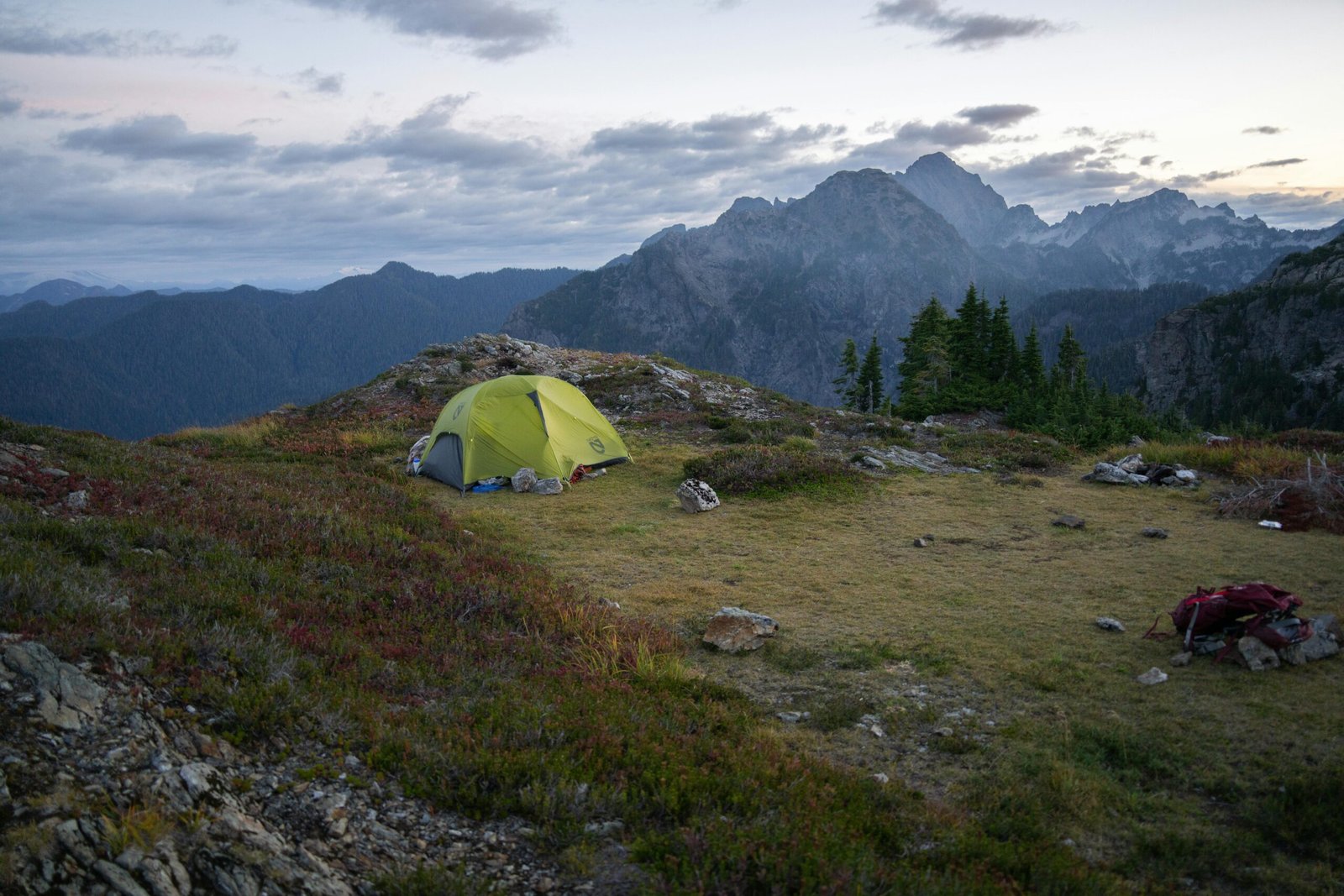
Wallowa Lake State Park

Image Source: Oregon State Parks
Towering 9,000-foot snow-capped mountains surround Wallowa Lake State Park on three sides. The park serves as a gateway to Oregon’s largest wilderness area. This alpine gem gives visitors a perfect basecamp for adventures in northeastern Oregon’s dramatic mountain setting.
Wallowa Lake State Park highlights
A large, crystal-clear glacial lake sits at the park’s heart and draws fishing and boating enthusiasts. The park’s waters boast record-setting kokanee salmon and impressive mackinaw (lake trout). The lake holds eight state fishing records and produced world-record kokanee. Visitors can enjoy spectacular mountain views and spot abundant wildlife in what locals call some of the Pacific Northwest’s most breathtaking scenery.
Wallowa Lake State Park hiking trails
The Wallowa Lake Trailhead lets you access Oregon’s largest wilderness—the Eagle Cap. Three main trails stretch into this wilderness area: Chief Joseph Trail, Aneroid Lake Trail, and West Fork Trail. You’ll find stunning waterfalls, wild roses, and mountain vistas along Chief Joseph Trail. The West Fork Wallowa River Trail takes you to Ice Lake, where you can capture picture-postcard photos after a steep climb.
Wallowa Lake State Park camping options
The park has 209 campsites with 121 full-hookup sites (36 pull-through), 88 tent-only sites, and two yurts (one pet-friendly). You can camp year-round, though winter months offer limited sites. Each site comes with a picnic table and fire ring. The park doesn’t allow generator use anywhere.
Wallowa Lake State Park accessibility
Two regular campsites and both yurts meet ADA standards. Several picnic tables in day-use areas are easy to access. The park’s bathrooms and showers accommodate wheelchairs. Universal access keeps improving through ongoing park developments.
Wallowa Lake State Park nearby attractions
The Wallowa Lake Tramway stands out as the area’s main attraction. It takes visitors up to the summit of 8,150-foot Mt. Howard for sweeping views. You can also explore the Eagle Cap Wilderness with its 50-plus alpine lakes, visit Chief Joseph’s Gravesite, or check out Joseph’s artistic community with its world-class bronze foundries.
Wallowa Lake State Park visitor tips
You’ll need reservations during summer since the park fills up in July and August. Stay alert around local wildlife—don’t feed deer or leave food out. Winter visitors should know that water runs only at specific frost-free spigots. Extra vehicles cost USD 7 per night, rising to USD 10 on July 1, 2025.
The Cove Palisades State Park

Image Source: Oregon State Parks
The Cove Palisades State Park sits in central Oregon’s heart, where the Deschutes and Crooked Rivers meet to create Lake Billy Chinook. This year-round destination stands out from Oregon’s coastal and forest parks with its high desert setting and striking basalt cliffs.
Cove Palisades highlights
Towering 500-foot canyon walls and vast juniper plateaus make the park look like something from the American Southwest. Lake Billy Chinook serves as the park’s crown jewel with its 72-mile shoreline perfect for boating, fishing, and swimming. Visitors can catch amazing views of the snow-capped Cascade Range from spots all over the park.
Cove Palisades hiking trails
The Tam-a-láu Trail stands as the park’s signature hike (6-7 miles round-trip) and climbs 600 feet through switchbacks to a plateau with breathtaking Cascade Mountain and canyon views. Hikers starting from Deschutes Campground will cover 6 miles, while those who begin at Upper Deschutes day-use area complete 7 miles. The relaxed Crooked River Rim Trail stretches 2 miles and shows off “The Island,” a 200-acre haven for raptors. Families love the flat quarter-mile Wetland Nature Trail Loop that winds through a restoration area.
Cove Palisades camping options
Two distinct campgrounds welcome visitors:
- Crooked River Campground (E Loop): 91 electrical sites with water stay open year-round
- Deschutes Campground (A, B, C Loops): Runs seasonally (May-September) with 87 full-hookup sites and 93 tent sites
The park also features three deluxe cabins with lake views, 21 boat moorages you can reserve, and three group tent sites. Each campsite’s fee covers parking for one vehicle, with an extra $7 nightly fee for additional vehicles.
Cove Palisades accessibility
Kayakers can launch easily from two accessible day-use areas. Six campsites are ready for visitors with disabilities. Most viewpoints remain available to everyone, though trail difficulty varies throughout the park.
Cove Palisades nearby attractions
Peter Skene Ogden State Scenic Viewpoint lets you peek into dramatic gorges from historic bridges. Smith Rock State Park, a world-class climbing destination, lies just a short drive south. Winter brings peaceful conditions that are perfect for fishing and birdwatching.
Cove Palisades visitor tips
You should book six months ahead, especially during busy summer months. Fire restrictions pop up often in this dry climate, so always check before your visit. The Crooked River Campground’s location, about a mile from the lake, needs careful thought when you plan your activities.
Devil’s Punch Bowl State Natural Area

Image Source: Oregon State Parks
Nature’s most dramatic spectacles await visitors at Devil’s Punch Bowl State Natural Area on Oregon’s central coast. This 5.34-acre day-use spot features a massive bowl carved from rock that opens to the churning Pacific Ocean. The sight of powerful waves and unique geology fascinates everyone who visits.
Devil’s Punch Bowl highlights
The park’s main attraction is a giant punch bowl-shaped hollow rock formation. Two sea caves collapsed and waves kept shaping it over time. The bowl comes alive during high tide, especially in winter storms. Ocean water crashes inside with thunderous roars that create a violent, foamy display. Adventurous visitors can explore the bowl’s interior when the tide is low and the water drains completely.
Devil’s Punch Bowl hiking trails
A 0.8-mile out-and-back trail with 62 feet of elevation gain lets you see this geological wonder up close. Most people complete this easy trail in about 18 minutes. Beach lovers can take a short paved path from the parking area to Otter Crest Beach, though parts of it have eroded. The path gives access to the punch bowl’s interior at low tide.
Devil’s Punch Bowl camping options
You won’t find camping spots at Devil’s Punch Bowl. All the same, several popular options are nearby. Beverly Beach Campground, South Beach State Park, and Devil’s Lake State Recreation Area welcome campers. These spots fill up fast in summer, so book ahead.
Devil’s Punch Bowl accessibility
The punch bowl viewpoint is easy to reach, but the beach trail and interior can be tough if you have mobility issues. Erosion damage has left a 4-foot drop on the steep beach access trail.
Devil’s Punch Bowl nearby attractions
The area has plenty to explore within minutes:
- Yaquina Head Outstanding Natural Area (2.1 miles away)
- Newport’s Historic Bayfront (1.4 miles)
- Nye Beach (0.8 miles)
- Agate Beach State Recreation Site (0.6 miles)
Devil’s Punch Bowl visitor tips
Check tide tables before your visit to safely enter the bowl at low tide. The rocks get very slippery, so wear shoes with good grip that can handle water. Three small lots provide the only legal parking spots. Street parking in nearby neighborhoods isn’t allowed. Marine life enthusiasts should head to the punch bowl’s north side during low tide to spot fascinating creatures in the tide pools.
Cape Blanco State Park

Image Source: Oregon State Parks
Cape Blanco State Park sits at Oregon’s westernmost edge, where historic treasures meet breathtaking coastal views. This rugged headland reaches further west than most points in the contiguous United States and draws visitors with its dramatic ocean setting.
Cape Blanco expresses
The state’s oldest lighthouse stands as the park’s crown jewel, built in 1870 and rising 245 feet above the Pacific Ocean. Two properties in the park are listed on the National Register of Historic Places – the lighthouse and Hughes House, an elegant Victorian farmhouse from 1898. Visitors can explore more than eight miles of hiking trails that lead to beaches, ocean viewpoints, and fishing spots along the Sixes River.
Cape Blanco hiking trails
A network of connected trails offers different challenge levels. The Pacific View Trail stretches one mile with an easy grade and shows off Cape Blanco against the Pacific backdrop. The Cape Blanco North Shore Trail runs a steep but rewarding half-mile path to the shoreline. The Hughes House Trail winds two miles through a beautiful valley toward the Sixes River.
Cape Blanco camping options
The campground has 52 electrical sites with water and four standard cabins you can reserve (two welcome pets). Horse lovers will find eight reservable sites in the horse camp – six with dual corrals and two with quad corrals. Each site’s fee covers one vehicle, with extra vehicles costing $7 per night (rising to $10 on July 1, 2025).
Cape Blanco accessibility
Visitors with mobility needs can use six campsites and one cabin. Paved paths make several viewpoints wheelchair-accessible, though beach access remains challenging due to natural terrain.
Cape Blanco nearby attractions
The charming town of Port Orford lies just minutes away with stunning coastal views. Humbug Mountain State Park beckons with great camping and hiking. The lesser-known Floras Lake delights visitors with kiteboarding, hiking, and a beach featuring orange rusted cliffs.
Cape Blanco visitor tips
Lighthouse tours run April through October (Wednesday-Monday, 10 a.m.-3:30 p.m.) and cost $2 for adults, while youth under 16 enter free. Storm winds at Cape Blanco can reach 100 mph, so visitors should come prepared for rough weather.
La Pine State Park

Image Source: Bend Oregon
La Pine State Park sits along the trout-filled Upper Deschutes River in a peaceful high desert subalpine forest. You can find this tranquil retreat just 7 miles north of La Pine and 21 miles south of Bend, which makes it a perfect basecamp to explore central Oregon’s natural wonders.
La Pine State Park highlights
The park’s star attraction is “Big Red,” Oregon’s largest ponderosa pine. This majestic 500-year-old heritage tree reaches 162 feet into the sky with a 28.9-foot circumference. The park has 14 miles of multi-use trails that connect major landmarks on both sides of the scenic river. The park offers year-round recreation – from summer fishing and floating to winter snowshoeing and cross-country skiing.
La Pine State Park hiking trails
The park’s trail network welcomes hikers, mountain bikers, and horse riders. The Big Pine Loop has a short, paved path that leads to the heritage tree and a quiet fishing spot. The McGregor Memorial Viewpoint looks over a scenic river bend and serves as an entry point to the park’s trail system. The Deschutes Loop and Fall River trails are favorite spots for mountain bikers.
La Pine State Park camping options
The campground has three distinct loops:
- South Loop (sites 1-44): Open year-round with full hookups
- Middle Loop (sites 50-96): Seasonal (May-October) with full hookups
- North Loop (sites 100-148): Seasonal (May-October) with water/electric hookups
The park offers ten cozy log cabins year-round – five rustic and five deluxe – as alternatives to tent camping.
La Pine State Park accessibility
All deluxe cabins and one rustic cabin welcome visitors with disabilities, though winter access varies. The South Loop Campers Clubhouse stays open all year from 8 a.m. to 9 p.m. and provides kitchen facilities and heating.
La Pine State Park nearby attractions
The park sits among Central Oregon’s iconic landmarks, including Deschutes National Forest, Newberry Crater, and Lava River Cave. A quick 15-minute drive takes you to the High Desert Museum, which offers an excellent educational experience.
La Pine State Park visitor tips
Water hookups at campsites and the RV dump station stay off from October through April. Remember to check for seasonal road closures – the Big Tree parking area and Deschutes Day-use Area close during winter months.
Carl G. Washburne Memorial State Park

Image Source: Oregon State Parks
Carl G. Washburne Memorial State Park sits behind a thick wall of native plants that blocks out highway noise. Visitors can enjoy the sound of ocean waves instead of traffic. You’ll find this coastal sanctuary 13 miles north of Florence on Highway 101, where forest peace meets Pacific Ocean views.
Washburne Park highlights
China Creek flows softly through the campground where wild rhododendrons put on a bright show each spring. The sound of crashing waves creates nature’s perfect lullaby at night. Elk often walk right through the grounds, giving campers amazing wildlife encounters. The park’s best feature is how quiet it stays while being close to major coastal spots.
Washburne Park hiking trails
The park has four main trails for hikers:
- Hobbit Trail: A magical 2.4-mile path through sitka forest that ends with small chutes through sand and plants – kids love this part
- China Creek Loop: A 5.1-mile route that takes you through moss-covered forests and crosses the creek several times
- Roosevelt Beach Loop: A 2.7-mile family-friendly loop that connects the campground to the sandy beach
- Valley Trail: Links both Hobbit Beach and the Heceta Head Lighthouse trail
Washburne Park camping options
The campground has about 50 full-hookup sites and more than five electrical sites with water. There are seven walk-in tent sites (closed from October to April), a hiker/biker camp, and two yurts (one allows pets). You’ll find flush toilets, free hot showers, and firewood you can buy. While yurts need reservations, all other sites work on a first-come, first-served basis.
Washburne Park accessibility
Campsite #30 works well for campers with disabilities. The trails from campsites come with different difficulty levels, so visitors with limited mobility can find paths that work for them.
Washburne Park nearby attractions
Heceta Head Lighthouse is just 2 miles south on Highway 101 and offers tours all year when weather allows. A trail goes under the highway to a five-mile sandy beach where you can watch whales, hunt for agates, and explore the shore.
Washburne Park visitor tips
The highway sign might say “campground full,” but spots often open up, especially Sunday evenings. Cell service is very weak in the area – AT&T users won’t get any signal. Several trails with different difficulty levels take you from the campground to the beach.
Lake Owyhee State Park

Image Source: Here is Oregon
Lake Owyhee State Park sits in Oregon’s eastern corner. This remote desert oasis features colorful volcanic canyon walls that surround a 53-mile-long reservoir. Most travelers haven’t found this secluded paradise yet. The park provides pristine boating and camping experiences along one of Oregon’s most dramatic canyon landscapes.
Lake Owyhee highlights
The Owyhee Reservoir is the park’s main attraction. It fills a narrow, deep canyon decorated with vibrant volcanic rock formations. You’ll need a boat to see most of the park’s impressive geology. The reservoir is perfect for fishing enthusiasts. They can catch largemouth bass, white and black crappie, and catfish. The reservoir also gets stocked with rainbow trout occasionally. The park serves as a peaceful escape from everyday life. You won’t find cell phone service or nearby amenities here.
Lake Owyhee hiking trails
The park’s signature hike runs along Fishermans Road. This 8.7-mile trail is challenging with 1,961 feet of elevation gain. Hikers can also explore Leslie Gulch nearby. A short scenic walk leads to its remarkable natural amphitheater surrounded by honeycombed rock faces.
Lake Owyhee camping options
Two distinct campgrounds meet different needs:
- McCormack Campground (seasonal: April-October): Has 29 electrical sites with water and 8 tent sites
- Indian Creek Campground (year-round): Provides 21 electrical sites with water and 2 cozy cabins
Both campgrounds come with fire rings and picnic tables. You can buy firewood and ice during the season.
Lake Owyhee accessibility
The park caters to visitors with mobility needs. ADA-compliant areas include cabins and sites #16, 17, and 31 at McCormack. Indian Creek offers accessible sites #59 and 60.
Lake Owyhee nearby attractions
Succor Creek State Natural Area attracts rockhounds. They often find thunder eggs, agates, and picture jasper here. Leslie Gulch’s impressive geological formations and the broader Owyhee Canyonlands draw off-road enthusiasts.
Lake Owyhee visitor tips
The park road can be tricky. Expect steep and narrow sections with sharp corners and limited visibility. You’ll find potable water only from April through October. Boaters should note that summer water levels might affect dock access.
Cottonwood Canyon State Park

Image Source: Oregon State Parks
The John Day River carved out Cottonwood Canyon State Park, Oregon’s second-largest state park. This stunning park includes over 8,000 acres of rugged terrain. Dramatic vertical cliffs and arid grasslands stretch for miles in every direction.
Cottonwood Canyon highlights
This vast landscape gives visitors a unique chance to find solitude and explore untouched nature. The park earned certification as an International Dark Sky Park in 2024, making it perfect for stargazing. Nature lovers often spot Rocky Mountain elk, mule deer, pronghorn antelope, white-tailed jackrabbits, and bighorn sheep roaming the area. The John Day River, one of Oregon’s longest undammed river systems, serves as both the visual centerpiece and recreational heart of the park.
Cottonwood Canyon hiking trails
The park features four main trails:
- Pinnacles Trail: 4.3 miles one-way (rated easy with 53 feet elevation gain), follows the John Day River downstream
- Lost Corral Trail: 4.3 miles one-way across the river, open to hikers, bikers, and equestrians
- Hard Stone Trail: 1.5 miles one-way upstream, restricted to foot traffic only
- Sage Steppe Trail: 0.7 miles of packed gravel with minor elevation gain
Cottonwood Canyon camping options
Lone Tree Campground provides 21 primitive sites for tents and self-contained RVs up to 75 feet. Guests can book one of four rustic cabins available throughout the year. The group tent area fits up to 25 people. Winter camping works on a first-come, first-served basis.
Cottonwood Canyon accessibility
Wheelchair access exists at several viewpoints and day-use areas. The park works to improve universal accessibility, though the rugged terrain creates natural limits.
Cottonwood Canyon nearby attractions
Clear days offer spectacular views of Mt. Hood, Adams, and Rainier from certain spots. The John Day Fossil Beds sit just north, showcasing Oregon’s remarkable paleontological history.
Cottonwood Canyon visitor tips
Cell coverage doesn’t exist anywhere in the park. Summer temperatures reach above 80°F, so bring plenty of water – about 20 ounces per person per hour. Remember that western rattlesnakes and cougars call this area home.
Wrapping up
Oregon’s remarkable state park system lets you find natural wonders from rugged Pacific coastlines to ancient forests and high desert canyons. These fifteen parks showcase the amazing diversity that makes Oregon a top outdoor destination. You can watch thundering waterfalls at Silver Falls, check out volcanic formations at Smith Rock, or enjoy stargazing at Cottonwood Canyon without any light pollution.
The parks have something for everyone’s comfort level. You can camp under starlit skies at Wallowa Lake, stay in cozy cabins at La Pine, or book yurts along the coast. Families love the easy-to-walk trails like Silver Falls’ North Rim path. Adventure seekers head straight for challenging routes like Smith Rock’s Misery Ridge Loop.
These parks are perfect gateways to memorable experiences where visitors can connect with nature while enjoying modern amenities. Wildlife watchers might spot Roosevelt elk at Carl G. Washburne Memorial State Park or bighorn sheep at Cottonwood Canyon. Wallowa Lake offers chances to catch record-setting kokanee salmon, and photographers can capture dramatic waves at Devil’s Punch Bowl.
These fifteen destinations show why Oregon’s park system ranks among America’s finest. While some facilities close in winter, many parks stay open year-round. This makes 2025 the perfect time to see these natural treasures in person. The natural beauty that began over a century ago lives on in these varied landscapes, ready for visitors to create their own Oregon adventure.
One thought on “Explore the Beauty: 15 Oregon State Parks You Need to See”
Comments are closed.